

WHY
RIFFAI?
RIFFAI, a Satellite & AI company that utilizes AI technology for monitoring environmental changes in Earth Observation.
With power of artificial intelligence, hyper-multispectral imagery, and times series analysis. we tackling one of the most pressuring challenges on Earth.


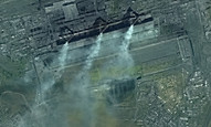
Satellite Intelligenece Powered by AI
Detecting environmental changes & Key critical infrastructure from
Earth observation with Deep Learning


RENEWABLE ENERGY
ENVIRONMENT
DEFENCE
INTELLIGENCE
URBAN
SETTLEMENT
INDUSTRY

Site Search & Selection
Area Segmentation
Adaptation Planning
Macro Management
Ground Movements
Specific Object Quantification
Risk Assessment
Qualified Lead
Weather Forecast
Long-Term Observation
Critical Sites Detection
Comand & Control
Precision Guidance
Mass Surveillance

BACKED BY OUR PARTNERS GLOBALLY
We are collaborating with industries, governments, and militaries.
RIFFAI is trusted and endorsed by the most experienced organizations in the domain of energy, intelligence, and environment. To deliver satellite monitoring that is rigorously proven, proactive, and specially trained to address the most challenging situations.
